
We've moved to Kenya!
You can follow our new blog here: http://africagwinners.blogspot.com/
Thursday, November 29, 2012
Monday, September 3, 2012
Farewell to Peru
As a final farewell to Peru, Britt and Valerie arranged a last visit and trek in the Sacred Valley. They started with a 2-day stay in Ollantaytambo to get acclimated to the altitude and to enjoy the charms of that town and its sites. Then they booked an 8-day trek with a local company called Qeros Tours. http://www.qerostours.com/choquequirao-trek/choquequirao-machu-picchu-trekking.html
The trek included a visit to the remarkable ruins of Choquequirao. They are considered to be like a smaller Machu Picchu, only far less visited, because they are only accessible on foot, via a 2-day trek.
The tour also goes through other amazing parts, winding across multiple ecosystems, into river valleys, and over high mountain passes. The trek also involves many hours of steep climbs and descents at high altitudes.
The trip was amazing. It offered a glimpse into the more hidden parts of Peru, which most of us never know about. It took Britt and Valerie to farms, villages, and places where everything is brought in on foot or on the backs of small, mountain pack mules. It introduced them to people who walk up and down steep mountains their whole lives, isolated from paved roads (or any roads), hot water, electricity, and much of the outside world. They retain the culture, language, and belief systems of their ancestors and of the land and night skies around them. It was humbling, beautiful, and exhausting. It was fun, new, and eye-opening.
There is a best-selling book by Mark Adams called Turn Right at Machu Picchu. As it happens, he takes the same trail as Britt and Valerie, though he goes even farther then they did to follow the footprints of Hiram Bingham. But his descriptions are very similar to the experiences of our fearless Gwinner couple. So, they recommend the book.
In the meantime, here is their story told in photos:
Arriving. Flying in from Lima to Cusco, B and V drove straight to the Sacred Valley. The drive is beautiful. This was Britt and Valerie's first time to visit during the dry season, when the hills are a patchwork of browns and golds. In contrast, the skies and mountains are shades of blue.


 They started off in Ollantaytambo, where the plaza in front of the ancient Inca citadel features colorful crafts and souvenirs.
 Ollantaytambo has two sets of ruins. On one side is the large citadel. On the opposite hillside are buildings that served as graineries and food reserves. Britt and Valerie climbed up to these to admire the sunset.

 The town of Ollantaytambo maintains its Inca foundations, visible in the stonework in the above photos, along with the original cobbled streets and grid-like layout.
 The ceramic bulls are features of rooftops throughout the Sacred Valley. They are essentially good luck charms.
 The ruins of the Ollantaytambo citadel start by the Plaza and fill the hillside.
 The stonework in more sacred parts is quite impressive. Large stones, quarried across the valley, are fitted together so well that they have withstood the tests of time, battles, and earthquakes.
 One afternoon, B and V signed up for a bike tour to visit local villages, known for their fine weaving. They ended up buying several pieces from this woman.
 The young lad on the right was an American volunteer, working in the village with a youth program to help with building projects.
 The villagers gathered in the school yard for a meeting with the mayor. After the meeting, they all headed home in their bright, traditional hats and carrying cloths.
 A man from the village
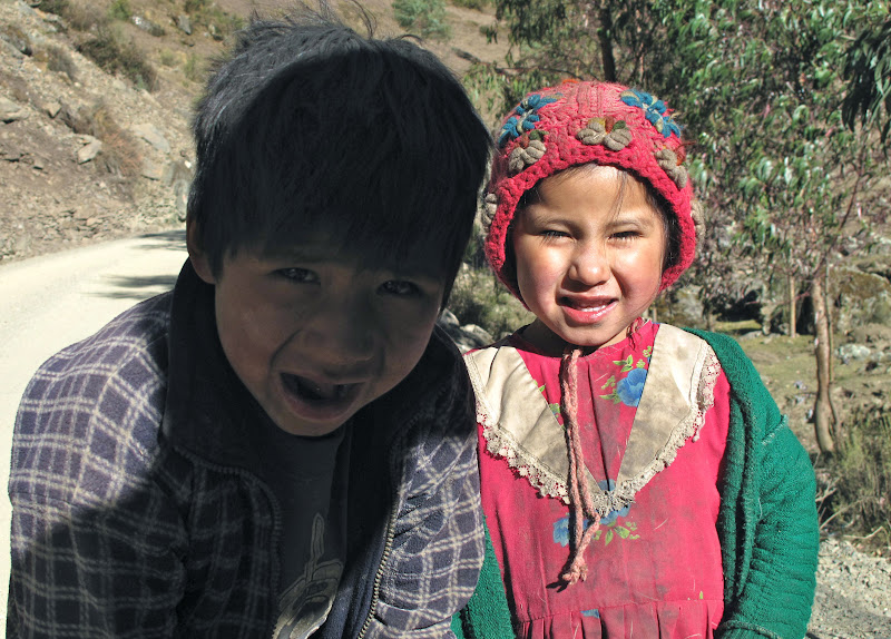
 Two small children were curious about Britt and Valerie's bicycles. They looked a bit like Hansel and Gretal, the the brother holding his small sister's hands carefully and protectively.
Day 1 of the trek.
 Britt and Valerie head off from the village of Cachora. Their mood is bright, the sky is clear, and there are spectacular peaks ahead.
 The terrain on Day 1 starts uphill, but is soon is relatively flat and easy - at least for the first several hours...

 As the day fades, the path becomes more steep and narrow. At least it is downhill. But night falls well before they have reached the campsite, so the last few hours are in the dark with flashlights. It is only the next day, that B and V are able to see the steep jagged line they had traversed, with scary drops on either side.

 This campsite rooster not only made sure to wake up our trekkers bright and early. It also took on Britt, when he tried to approach the pile of recyclables.
Day 2. To Choquequirao
 Their first campsite was on the Apurimac River. The river is impressive with plenty of water and a strong current. Massive flooding in January-February of 2010 on this river and others, due to an El Nino, wiped out villages, crops, roads, train tracks, and more. There were deaths, and the way in and out of Aguas Calientes (village below Machu Picchu) was closed for months. Though much has been restored and rebuilt since then, the bridge that formerly had crossed the Apurimac on the way to Choquequirao has yet to be replaced. Instead, there is a suspended basket-thing for ferrying people and provisions. Basically, you start off with a good push, let gravity take you as far as it will, then pull yourself to the opposite bank with a system of pulleys. It was a wild ride. B and V loved it.
Because you can't put pack animals on this contraption, the tour company had to arrange a separate set of mules/horses to meet the trekkers on the other side of the river, while the first group headed back to Cachora. For the second team, this meant a several day journey just to meet up with the trekkers, plus the multi-day trek back and beyond their starting point.
 The trek up to Choquequirao takes about 1/2 a day. It is all uphill - a vertical climb of about a mile - but mostly shaded. The path is dusty dirt with rocks this time of year. Occasionally, there are steps.

The mules, cook, and horsemen are very accustomed to the terrain and climb up quickly. In fact, Cirilo, the cook, does the first two days of the trek at a trot, carrying several dozen eggs in a plastic grocery bag.
They pack up the campsite, pass B and V with their guide, and get to the next campsite well before our valiant trekkers. They fix a late lunch and laugh at B and V, as they take advantage of the ice-cold showers to get off at least some of the day's dust. (This will increasingly prove to be a losing battle as the days go on.)
 B, V, and their guide spend the late afternoon exploring Choquequirao. They have the place to themselves. Estimates are that only 20-30% of the site has been uncovered. And what's visible is already pretty impressive.
 Our trekkers are also joined by Paol, their junior horsemen, who is on school holiday and accompanying his father to take care of the pack mules and extra "emergency" horse. (Because the only way in and out is on foot, an extra horse is included to carry anyone who becomes sick or injured - which proves to be a good thing later.)

 Ruben, the patient and fearless guide, pals with Paol, the intrepid junior horseman
 Above the site of Choquequirao is a mountaintop, flattened by the Incas to create a ceremonial circle, surrounded by stunning views.
 On one of the very steep sides of the site, there is a series of narrow terraces. Paol practically danced down the steps from one to the next, while B and V carefully made their way down.
 The lower, narrow terraces are decorated with white, stone llama figures. These were only re-discovered in 2005, as they had been hidden under layers of jungle vegetation for hundreds of years.
 This photo gives you a sense of the steepness of the terraces and terrain.
 The sun sets and the mountains show their colors.
 Day 3: The next morning, B and V get to go through the ruins again, before continuing uphill for a bit and then down for lunch along the Rio Blanco.
 They take in more views
 and head downhill through jungle, bamboo, and dryer stretches.
 The bamboo is a favorite food of the Spectacled Bear, whose habitat they pass through. At one point, B and V clearly hear the sound of munching, but they don't actually see a bear.
 They pass another Inca site, with terraces and fountains capturing water from a natural spring.
 The terrain becomes more hot and dry. At the very bottom, in the left of
this photo, is the Rio Blanco. It has a mild current and cool water,
which is quite a relief for our sweat drenched trekkers. They jump in
the water to cool off, but end up covered in bug bites from the insects
that also take advantage of the water
The terrain becomes more hot and dry. At the very bottom, in the left of
this photo, is the Rio Blanco. It has a mild current and cool water,
which is quite a relief for our sweat drenched trekkers. They jump in
the water to cool off, but end up covered in bug bites from the insects
that also take advantage of the water

 Lunch is by the river, but the evenings campsite is way up on the next mountain top. So, the afternoon is spent hiking uphill for about 5 hours. It's worth it though. The campsite is at a lovely farm with stunning views.

 The sky offers another spectacular sunset - and then millions of stars with a bright Milky Way and southern constellations.
 The campsite is at over 4,000 meters. The nights are cold, but made merry buy a surprise bottle of wine offered by the Qeros companeros.
Day 4 - the pack mules and horse are ready for a new day - and more climbing. The nearest village, Yanama, is a day's trek away, over a pass at nearly 5,000 meters, and back down into a valley. And it's another day beyond that to the nearest (dirt) road.

 Cirilo the trek's chef is not only a master of making meals out of packed rations, he's also a farmer (during the rainy season). On the morning of Day 4, he helped the local farmer family to innoculate their cows before heading out at his usual trotting pace to face another day's trek.


 In Yanama, B and V got to meet Paol's younger sister and brother - along with a host of other relatives, whose farms were close by.
Day 5.
Work is underway to build a dirt road to Yanama from the town of Totora, on the other side of the Yanama Pass. For now the access is entirely by foot or mule/horse. This means any goods, building materials, food, etc have to be carried in or out by hand or on an animal.
B and V were only carrying day packs, but B had also picked up a nasty stomach bug at this point, so the trek was especially difficult for him this day. He barely had the strength to manage the morning's trek, which was fortunately a fairly leisurely climb.

 The scenery was impressive and made all the more dramatic by the fires being set in fields in preparation for spring planting.
 After a break for lunch, our trekkers had to climb over the Yanama Pass. Valerie, feeling particularly good that day, headed off with the guide Ruben and made it there at a respectable pace.
 Unable to keep down food, Britt made it over the pass on the "emergency horse" - demonstrating the wisdom of having this extra animal along. In the background of the photo you can see men on the path carrying long planks on their shoulders - the only way to get building material to Yanama until the new road is completed.
Day 6.
At this point of the trip, our trekkers had the option of walking or taking a day off and traveling by combi (small bus) to the natural hot springs of Santa Teresa. Well, the choice was not difficult.
They allowed themselves a day of rest and recovery - not to mention the chance to clean off at least some of the accumulated grime - at the hot springs. This is also the spot where their trek met up with the far more popular (and populated) Salkantay Trek. It was a fine opportunity to meet other trekkers - most of them (though not all) far younger than B and V.
 Day 7 - on to Aguas Calientes
 Most people arrive in Aguas Calientes (the town below Machu Picchu) via train from Ollantaytambo. Some hike in from the famous Inca Trail. And a small minority come around the back way. It follows the trail originally taken by Hiram Bingham and now serviced by a daily train from the hydroelectric station (which supplies power not only to this area but to several surrounding provinces) to Aguas Calientes. The train accepts passengers. But most hikers (off the Salkantay or Choquequirao trails) prefer to leave their packs with a team member (in B and V's case the fearless Cirilo) who takes the train, and hike the 3 or so hours along the train tracks to admire the views. It's a fascinating way to see Machu Picchu (from below) and its environs. And its mercifully flat.
Day 8- Machu Picchu
This was not B and V's first trip to Machu Picchu. But it was the first time they'd seen it in the dry season and under a bright blue sky. In the rainy season, Machu Picchu takes on a mysterious, romantic feel. In the dry season it shines. In either case, it does not fail to amaze the visitor with its spectacular location, stonework, and very existence.
 Britt and Ruben, "we made it!"
 Morning light on the agricultural sector
 The quiet before the deluge of tourists
 Majestic mountains
 A view, what a view...
 Clear skies let you see the ice capped ridges of sacred mountains
 Enormous stones and jagged peaks
 A mirror to observe the night sky
 The perilous path to the Inca Bridge carved and built into sheer cliff
 A classic pose

Whew!
The trek included a visit to the remarkable ruins of Choquequirao. They are considered to be like a smaller Machu Picchu, only far less visited, because they are only accessible on foot, via a 2-day trek.
The tour also goes through other amazing parts, winding across multiple ecosystems, into river valleys, and over high mountain passes. The trek also involves many hours of steep climbs and descents at high altitudes.
The trip was amazing. It offered a glimpse into the more hidden parts of Peru, which most of us never know about. It took Britt and Valerie to farms, villages, and places where everything is brought in on foot or on the backs of small, mountain pack mules. It introduced them to people who walk up and down steep mountains their whole lives, isolated from paved roads (or any roads), hot water, electricity, and much of the outside world. They retain the culture, language, and belief systems of their ancestors and of the land and night skies around them. It was humbling, beautiful, and exhausting. It was fun, new, and eye-opening.
There is a best-selling book by Mark Adams called Turn Right at Machu Picchu. As it happens, he takes the same trail as Britt and Valerie, though he goes even farther then they did to follow the footprints of Hiram Bingham. But his descriptions are very similar to the experiences of our fearless Gwinner couple. So, they recommend the book.
In the meantime, here is their story told in photos:
Arriving. Flying in from Lima to Cusco, B and V drove straight to the Sacred Valley. The drive is beautiful. This was Britt and Valerie's first time to visit during the dry season, when the hills are a patchwork of browns and golds. In contrast, the skies and mountains are shades of blue.


Day 1 of the trek.


Day 2. To Choquequirao

Because you can't put pack animals on this contraption, the tour company had to arrange a separate set of mules/horses to meet the trekkers on the other side of the river, while the first group headed back to Cachora. For the second team, this meant a several day journey just to meet up with the trekkers, plus the multi-day trek back and beyond their starting point.


The mules, cook, and horsemen are very accustomed to the terrain and climb up quickly. In fact, Cirilo, the cook, does the first two days of the trek at a trot, carrying several dozen eggs in a plastic grocery bag.
They pack up the campsite, pass B and V with their guide, and get to the next campsite well before our valiant trekkers. They fix a late lunch and laugh at B and V, as they take advantage of the ice-cold showers to get off at least some of the day's dust. (This will increasingly prove to be a losing battle as the days go on.)


The farm and farmers are very welcoming, happy to sell (and pluck) one of their hens for supper.
.

Day 4 - the pack mules and horse are ready for a new day - and more climbing. The nearest village, Yanama, is a day's trek away, over a pass at nearly 5,000 meters, and back down into a valley. And it's another day beyond that to the nearest (dirt) road.


In the book Turn Right at Machu Picchu the author describes how his guide explains that your body starts to fall apart around day 3 of a trek if you are not used to the kind of workout it demands. The endless walking, high altitudes, steep inclines up and down do take a toll if you haven't spent years and years doing this kind of exercise - even for people who try to remain relatively fit. B and V did well through day 3. But on this day 4, the endless climbing and thin oxygen began to get the better of them. Valerie was the first to feel it. Her ankles and feet became swollen from the altitude. It was benign but annoying. It was on this day that, after a morning of being in the lead, she started to slip behind the others, finally saying to Britt, "can we take a short rest at the next flat spot" - to which he responded, "Uh, there isn't one." Their ever patient and encouraging guide kept calling the "super hikers" and urging them to continue "slowly, slowly".
Just as Valerie (and maybe Britt, too) was wondering why she'd gotten herself into this crazy "challenging" trek, they reached the summit of the San Juan pass. And their good humors returned. The views were spectacular. The sky was blue. And they were surrounded by spectacular glacier-covered peaks. Ah yes, this is what it's all about.
A long descent down the other side brought them to the small village of Yanama, where they camped on a farm belonging to the family of the horsemen who had been accompanying B and V since the Apurimac River. Roger, the horsemen, not only has a traditional farm but also raises river trout. So the meals were particularly delicious.


Day 5.
Work is underway to build a dirt road to Yanama from the town of Totora, on the other side of the Yanama Pass. For now the access is entirely by foot or mule/horse. This means any goods, building materials, food, etc have to be carried in or out by hand or on an animal.
B and V were only carrying day packs, but B had also picked up a nasty stomach bug at this point, so the trek was especially difficult for him this day. He barely had the strength to manage the morning's trek, which was fortunately a fairly leisurely climb.


Day 6.
At this point of the trip, our trekkers had the option of walking or taking a day off and traveling by combi (small bus) to the natural hot springs of Santa Teresa. Well, the choice was not difficult.
They allowed themselves a day of rest and recovery - not to mention the chance to clean off at least some of the accumulated grime - at the hot springs. This is also the spot where their trek met up with the far more popular (and populated) Salkantay Trek. It was a fine opportunity to meet other trekkers - most of them (though not all) far younger than B and V.


Day 8- Machu Picchu
This was not B and V's first trip to Machu Picchu. But it was the first time they'd seen it in the dry season and under a bright blue sky. In the rainy season, Machu Picchu takes on a mysterious, romantic feel. In the dry season it shines. In either case, it does not fail to amaze the visitor with its spectacular location, stonework, and very existence.


Whew!
Subscribe to:
Comments (Atom)